
Hikes to Waterfalls
Looking for a fun hike? Try taking a path that leads to one of the many waterfalls in the Roanoke Region.
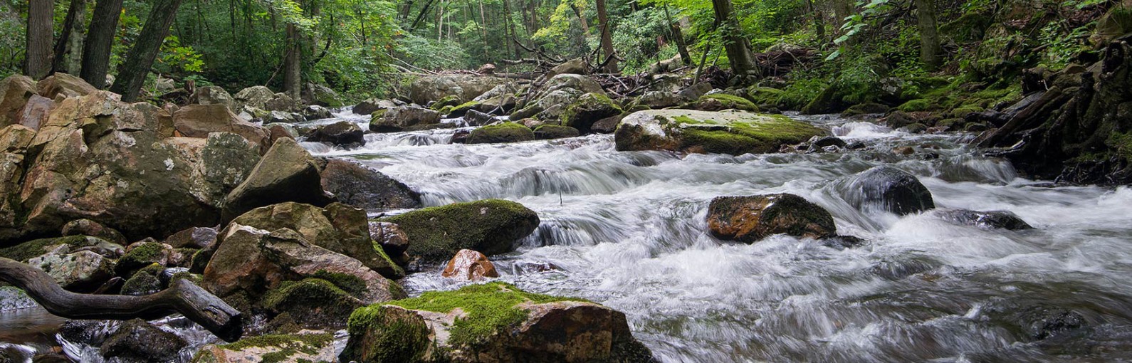
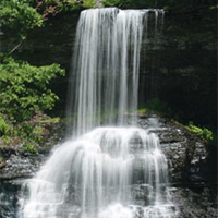
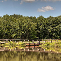
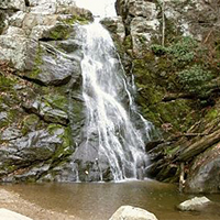
These rewarding hikes end with some spectacular views (and a place to get your toes wet.) Some of these waterfall hikes include Bottoms Creek Gorge, Roaring Run (pictured), the Cascades and Apple Orchard Falls. Not sure which hike is for you? We’ve got a complete list of waterfall hikes and route information to make planning easier.
Speaking of planning, make sure to think about your hike before leaving home and gather a few supplies. Here are a few pointers:
- Make sure to take plenty of water with you.
- Pack a small snack and make sure you have somewhere to stow any trash.
- Take your time. Hiking is not a race. Enjoy the scenery as you make it to your waterfall spot.
- Check the forecast before you head out.
- Prepare a small first aid kit for scrapes and cuts.
- Wear supportive shoes, sunglasses, and a hat.
- Be aware of your surroundings and be careful if you take photos to avoid trips and falls.
Find Your Waterfall Trail
Hikes to Waterfalls
-
Apple Orchard Falls


 Apple Orchard Falls is one of Virginia’s tallest and most spectacular waterfalls. Singing streams, dancing down cascades, huge boulders, and thick stands of forest surround stunning vistas and towering bluff lines. The 7.5-mile loop trail is moderately difficult.
Apple Orchard Mountain was named for the nature of the dominant northern red oak forests on its summits and ridges. The weather is so severe on the upper elevations of the mountain that the trees have taken on a stunted appearance, as if they have been trimmed and pruned over the decades.The Appalachian Trail and the Blue Ridge Parkway pass within a short distance of the top of Apple Orchard Mountain.
-
Blue Suck Falls
 The Blue Suck Falls Trail is an 8-mile moderate to difficult multi-use trail that connects several of the trails in the northwest region of the park to the trail head near the visitor center at Douthat State Park.
The falls and trail get their unusual name from the Appalachian term for a whirlpool or a “suck,” which may be found at the base of the falls. At higher elevations, the trail traverses the ridge top, often along a narrow path, and connects to the George Washington National Forest trail network. The trail features several east facing overlooks of the Alleghenies such as Lookout Rock. A highlight of the trail are the views of Blue Suck Falls. This rocky trail is actually steeper and more difficult at lower elevations.
-
Bottom Creek Gorge Preserve
 Forming the headwaters of the Roanoke River, Bottom Creek Gorge boasts spectacular scenery including the second highest waterfall in Virginia, virgin hemlocks, and hundreds of wildflowers.
Bottom Creek is a powerful mountain stream that forms a stair-step series of broad-basin waterfalls known as the “kettles.” One of the headwater streams of the South Fork of the Roanoke River, Bottom Creek boasts a 200-foot high waterfall. Flanking Bottom Creek are forests of mixed hardwoods (tulip poplar, maple, oak, hickory) and upland meadows. Five rare species thrive in this habitat.
NOTE: Dogs are not permitted at Bottom Creek Gorge Preserve.
-
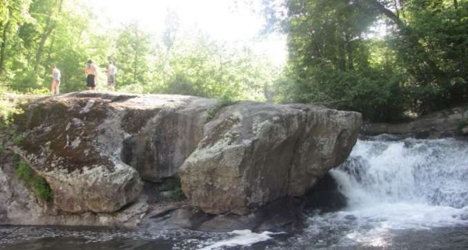
Cascade Falls Trail
 The trail leads to Cascade Falls, one of the most beautiful waterfalls (69 feet) in Virginia and possibly on the entire East Coast. Little Stony Creek cascades over a vertical cliff in several different streams.
- ~ 3.5 miles in length, out and back hike
- Easy to moderate difficulty
- There is a day-use fee of $3 (cash only)
- Map kiosk at trailhead (straightforward hike)
-
Crabtree Falls
Crabtree Falls is arguably the most beautiful set of waterfalls in Virginia. Billed as the tallest waterfalls east of the Mississippi, Crabtree Falls is a must-see for anyone who lives in the mid-Atlantic region.
Arrive at the top of the falls just 1.1 miles from the parking area and cross over a wooden bridge to an overlook. From here you can’t see Crabtree Falls below as it falls away, but there is still a nice view of the valley floor and the Blue Ridge Mountains. Don’t be tempted to climb over the stone wall onto the uppermost portion of the falls. The rocks are covered with very slippery algae.
-
Dismal Falls
 Dismal Falls is a 15-foot, multi-tiered waterfall on Dismal Creek. It is easily accessed from the road or from a side trail off of the Appalachian Trail.
Dismal Creek is about 50 feet wide (depending on water volume) at this point as it flows down over several ledges. The ledges on the left side of the falls are step-like while the middle and right ledges are more of a straight drop. In lower water, the middle and right are not covered and the stream is much narrower. Despite the width of the stream, the waterfall is not particularly open with trees lining each bank and throwing much of the falls into shade most of the day.
-
Falling Spring
 Falling Spring Falls is a breathtaking 80-foot waterfall that is one of the most visited and photographed spots in the Alleghany Highlands. The waterfall is on Route 220, just 5 miles north of Covington. This is one of the largest waterfalls in Virginia and cascades from an overhanging ledge that is visible from the roadway.
Thomas Jefferson described Falling Spring as a “remarkable cascade … falling over a rock about 200 feet to the valley below.”
-
Falls Ridge Natural Preserve
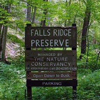 Falls Ridge Natural Preserve features two trails totaling 5 miles. With its nice hiking trails, beautiful waterfall, intriguing caves, rare plants, and convenient location, the Falls Ridge Preserve gets lots of attention. Falls Ridge Preserve is owned and protected by The Nature Conservancy.
Part of a steep, rugged ridge that rises from the valley of the North Fork of the Roanoke River, Falls Ridge Preserve boasts a spring-fed travertine waterfall approximately 80 feet in height.
Salem Fault runs through the preserve, dividing it into two different rock types-Precambrian limestone and shale/sandstone. The corresponding difference in soil types generates a diversity of vegetation, particularly wildflowers and smaller flora.
The rocks in the travertine falls watershed grew steadily, as minerals and lime dissolved in the water precipitate upon them. Over thousands of years, the build-up of calcium carbonate steepened the stream’s gradient and slowly created both the waterfall and one of the largest-known exposed travertine deposits. Large sinkholes on part of the land also indicate the existence of underlying caverns which have never been explored.
NOTE: Dogs are not permitted at Falls Ridge Natural Preserve.
-
Fenwick Mines
 Fenwick Mines was once an old mining area and is now home to trails and a recreation park. The trail takes you by open pit mines and foundations of old mining structures.
The Fenwick Forest Walk is a 1-mile nature trail. The wetland trail allows you to observe wetlands created by beavers; follow the trail through wetlands and open forests to see a variety of wildlife and vegetation that live in this environment.
The trails are wheelchair accessible. The site has a large picnic shelter, grills, toilets, and a fishing pond.
-
Mill Creek Falls
 From the parking area, keep to the left side of the stream and head up the gravel road. You’ll soon come to the Mill Creek dam, which has a shelter and picnic area. Continue to stay to the left of the stream, as the gravel road turns into a rocky trail here. Stay on the trails closest to the stream (marked by signs that say “waterfalls”) and soon you will arrive at the first of three falls. The second and third waterfalls are marked spur trails off to the right of the trail.
To go to Sentinel Point, continue on the trail past the waterfalls and you will intersect the “Piney Road Trail.” Turn right onto the trail, then turn right again onto “Shortcut.” After 0.33 miles this trail intersects “Grassy Road.” Turn right and ascend the steep hill for a great view of the town of Narrows and the New River.
Simply retrace your steps back down Grassy Road, left on Shortcut, left on Piney Road Trail, left on Catwalk, then stay by the stream to return to your car.
-
Panther Falls
Popular swimming hole and water fall Panther Falls is very easy to get to. It’s just under a half mile hike from the parking lot.Panther Falls is located on the Pedlar River just off the Blue Ridge Parkway. The 10 foot waterfall is bordered by two rocks that give you a great view of the refreshing pool of water. Use caution when swimming at there are undercut rocks and strong currents can make it difficult to get out of the water.
-
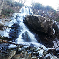
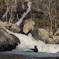
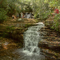
Roaring Run
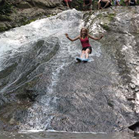 Roaring Run is an excellent hiking trail for the whole family. The easy, well-marked trail begins at a historic iron furnace and winds back and forth along the Roaring Run stream. You will pass rock walls, cascading water, and cross five footbridges before ending at beautiful Roaring Run Falls.
It is also a great trout stream with a natural water slide at lower levels. At higher levels, it becomes a Class V+ creek.
- Easy (out and back hike)
- Approximately halfway to the falls is a natural water slide
- Toilets and picnic area with charcoal grill
-
Stiles Falls
 Stiles Falls is a 40-foot waterfall located on Camp Alta Mons property. The trail is closed to the public while summer camp is in session.
The hike is about 3 miles long. From the camp office, walk up the road past the swimming pool, the retreat center, and the pond. Continue along the dirt road until you come to a sign indicating “Falls.” Follow the trail to the falls crossing the creek three times before reaching the falls. The trail is marked with white blazes.

Create Your Own Land Adventure
Get Started Powered by Roanoke Outside